QGIS Plugins
-
Intro
-
How to install plugins
-
Resources for plugins
-
Useful links
Information
| Primary software used | QGIS |
| Software version | 1.0 |
| Course | QGIS Plugins |
| Primary subject | Geospatial and Geographic Information Systems |
| Secondary subject | Geospatial and Geographic Information Systems |
| Level | Beginner |
| Last updated | November 27, 2024 |
| Keywords |
Responsible
| Teacher | |
| Faculty |
QGIS Plugins 0/3
QGIS Plugins
This section contains information on how to install and use plugins, it also covers some useful plugins
More functionalities can be added to QGIS by installing plugins. These can be downloaded from the QGIS Plugin Manager. The first set of tutorials addresses the installation of plugins and mentions some useful ones. Then, each set of tutorials covers one specific plugin.
QGIS Plugins 1/3
How to install pluginslink copied
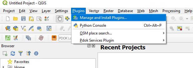
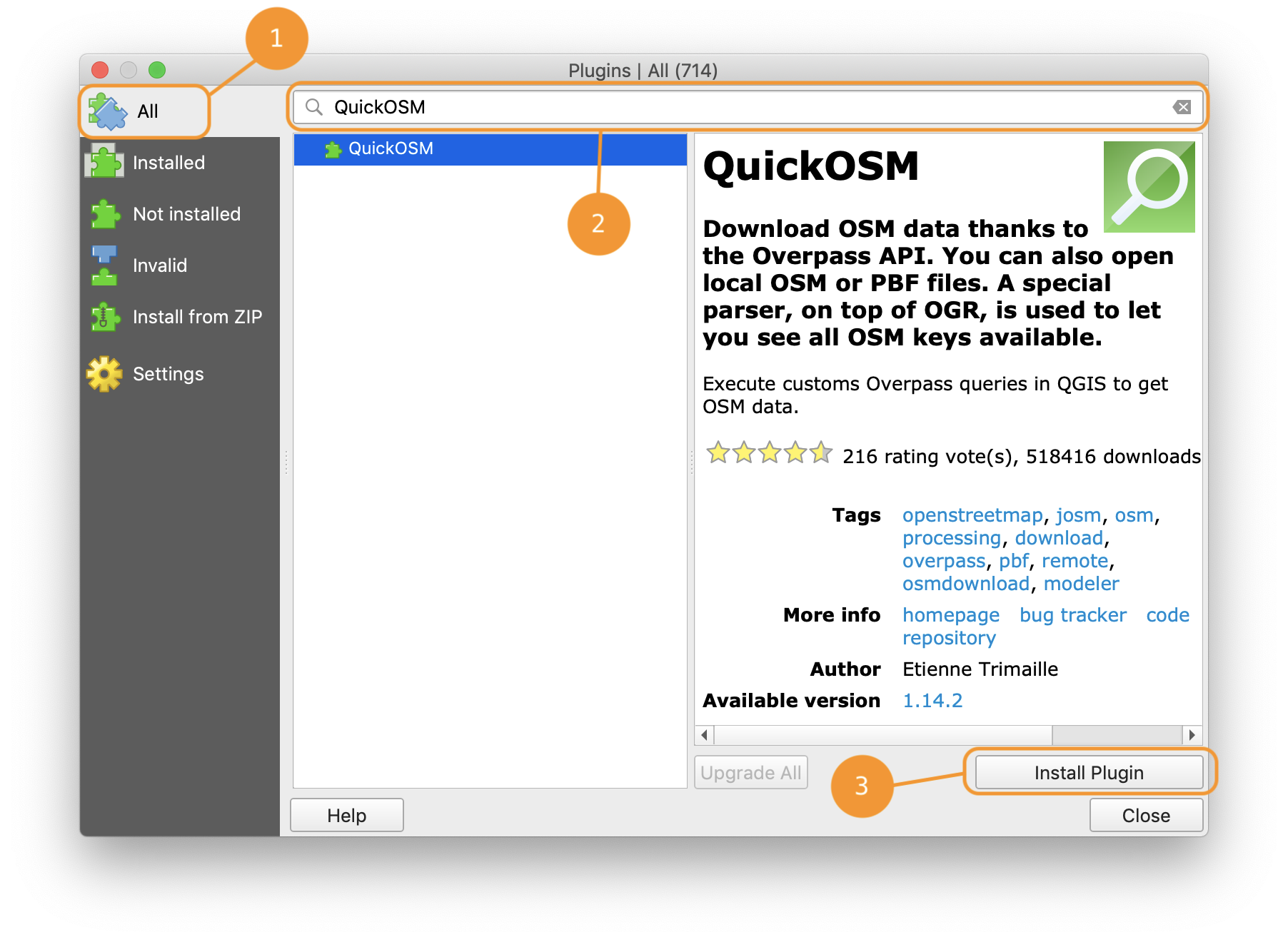
A plugin can be installed by following these simple steps:
Step 1: Go to Install Plugins in the QGIS menu.

Step 2: Click on the tab “All” on the left-side of the window that opens.
Step 3: Search for the plugin and select it from the results.
Step 4: Click “Install Plugin” and close the window.
Common issues
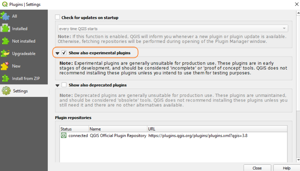
Can’t find a plugin in the search results?
Check if experimental plugins have been allowed in the plugin settings:
- Go to Install Plugins in the QGIS menu.
- Click on the tab “Settings” in the plugins window.
- Check the option “show also experimental plugins”.
For more information, see this useful QGIS tutorial.
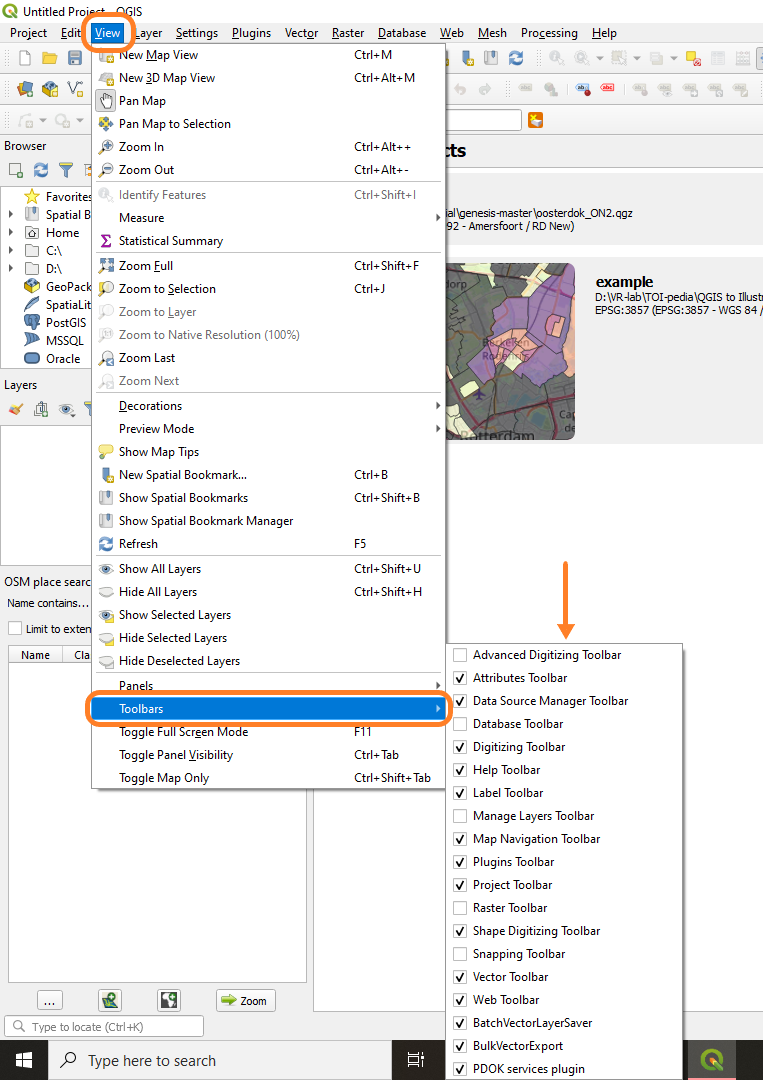
Can’t find a plugin after installation?
- Sometimes it can be quite difficult to find a plugin after installation because it is not automatically shown in the toolbar.
- To find an installed plugin, go Toolbars and select the one you are looking for from the list. It will then be shown in the toolbar.
Updating plugins
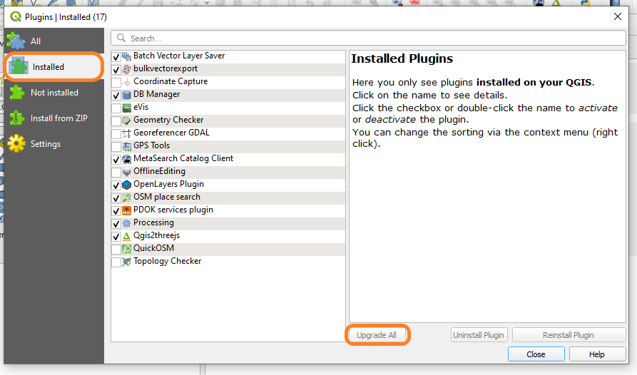
- Make sure to keep your plugins up-to-date by going to Installed and clicking on “Upgrade All”.
Other resources
- Understand and install plugins
QGIS Training manual: “9.1. Installing and Managing Plugins”
you can access this manual using this link
Language(s): EnglishChapters:
-
- follow along: managing plugins
- follow along: installing new Plugins
- follow along: configuring additional plugin repositories
- in conclusion, what’s next
- Install plugins
Mariëlle Geers-Plasmans (Geojuffie): “P01 Plugins installeren”
you can access this video using this link
Language(s): Dutch
Time: 10min 49s
- Introduction to user interface and plugins
Erik Meerburg (3D geoinformation research group): “Urbanism GIS Course 2: QGIS Settings and Plugins”
you can access this video using this link
Language(s): English
Time: 11min 26sChapters:
-
- intro (start-0:53)
- user interface (0:52-6:34)
- plugins (6:34-end)
- Useful plugins
QGIS Training manual: “9.2. Useful QGIS Plugins”
you can access this manual using this link
Language(s): EnglishContent:
- follow along: the QuickMapServices Plugin
- follow along: the QuickOSM Plugin
- follow along: the QuickOSM Query engine
- follow along: the DataPlotly Plugin
- in conclusion
- what’s next
- Useful plugins
Ujaval Gandhi: “Using Plugins (QGIS3)”/ “Plug-ins gebruiken (QGIS3)”
you can access the English tutorial using this link
you can access the Dutch tutorial using this link
Language(s): English, DutchChapters:
- overview of the task
- procedure
- Introduction to user interface and plugins
Erik Meerburg (3D geoinformation research group): “Urbanism GIS Course 2: QGIS Settings and Plugins”
you can access this videa using this link
Language(s): English
Time: 11min 26s
Chapters:- intro (start-0:53)
- user interface (0:52-6:34)
- plugins (6:34-end)
QGIS Plugins 2/3
Resources for pluginslink copied
ORS (Open Route Service) plugin
Openrouteservice is useful for routing, creating isochrones and perform complex matrix calculations.
- How to work with the ORS plugin: example with commercial travellers
Mariëlle Geers-Plasmans (Geojuffie): “ORS plugin”
you can acces this video using this link
Language(s): Dutch
Time: 18min 36s
PDOK (Publieke Dienstverlening Op de Kaart/Public Services On the Map) plugin
PDOK is a platform offering reliable geographical data of the Netherlands. This data is provided by Dutch authorities.
- How to work with the PDOK plugin
Mariëlle Geers-Plasmans (Geojuffie): “P02 PDOK plugin”
you can access this video using this link
Language(s): Dutch
Time: 4min 41s
Qgis2threejs plugin
Qgis2threejs visualizes DEM and vector data in 3D on a web view.
- Visualise a layer in 2.5D
Hans van der Kwast: “Using the Qgis2threejs plugin to visualise GIS layers in 2.5D”
you can access this video using this link
Language(s): English
Time: 1min 49s - Create 3D model using the QGIS2threejs plugin
Erik Meerburg (Geogoeroe): “verbeterde versie 3D model ALX maken”
you can access this video using this link
Language(s): Dutch
Time: 5min 39s
Potree and Qgis2threejs plugin
Potree renders large pointclouds and Qgis2threejs visualizes DEM and vector data in 3D on a web view.
- Pointcloud visualisation
Hans van der Kwast: “Pointclouds in QGIS using Potree and Qgis2threejs plugin”
you can access this video using this link
Language(s): English
Time: 7min 2s
Chapters:- introduction (start-0:34)
- installation (0:34-4:39)
- Qgis2threejs (4:39-end)
Profile Tool plugin
The profile tool plugin allows to generate the elevation profiles of a raster or point vector layer.
- Plot terrain profiles
Hans van der Kwast: “Using the Profile Tool plugin in QGIS”
you can access this video using this link
Language(s): English
Time: 3min 33s
LASTools plugin
LASTools provides a set of tools to manage LiDAR data (e.g. classify, filter, raster, clip, triangulate).
- Generate a digital surface model (DSM) from a city
Hans van der Kwast: “Generate a DSM from a point cloud in QGIS using the LASTools plugin”
you can access this video using this link
Language(s): English
Time: 14min 27s
DataPlotly plugin
DataPlotly is a Python plugin that is able to create plots.
- Match layer legend colours with histograms or pie charts
Hans van der Kwast: “Match Layer Legend Colours with DataPlotly Pie Chart Legend in QGIS”
you can access this video using this link
Language(s): English
Time: 5min 2s - Create pie charts from vector data
Hans van der Kwast: “Create Pie Charts in QGIS with the Data Plotly Plugin”
you can access this video using this link
Language(s): English
Time: 4min 36s
- Match colours of the legend of a Data Plotly chart with the ones of the layer
Hans van der Kwast: “Match QGIS Data Plotly Legend with Colours of the Layer (Update)”
you can access this video using this link
Language(s): English
Time: 1min 49s
PyQGIS plugin
PyQGIS allows to write and run Python scripts in QGIS.
- Create a table with stage (level) and volume in DEM
Hans van der Kwast: “Create a stage volume curve with PyQGIS”
you can access this video using this link
Language(s): English
Time: 12min 12s
Chapters:- introduction (start-1:45)
- coding (1:45-7:10)
- processing (7:10-end)
WAPlugin plugin
The WAPlugin allows access to WaPOR (WAter Productivity through Open access of Remotely sensed derived data) data.
- WAPlugin version 2.0 demonstration
Hans van der Kwast: “Open Data Day 2022 – Launch WAPlugin 2.0”
you can access this video using this link
Language(s): English
Time: 50min 48sChapters:
- introduction (start-6:44)
- install WAPlugin (6:44-8:13)
- configure backdrop with MapTiler plugin (8:13-10:30)
- getting the API token from FAO WaPOR (10:30-14:05)
- downloading data from the WaPOR catalogue (14:05-32:24)
- using the Indicators Calculator (32:24-38:45)
- WAPlugin documentation (38:45-48:18), closing (48:18-end)
SRTM Downloader Plugin
SRTM Downloader Plugin downloads SRTM (Shuttle Radar Topography Mission) Tiles, which contain elevation data, from the NASA server.
- Download SRTM 1-Arc Second DEM Tiles
Hans van der Kwast: “Download SRTM DEM Tiles with the SRTM Downloader Plugin in QGIS”
you can access thhis video using this link
Language(s): English
Time: 2min 9s
WebODM
WebODM helps to process drone images and create maps, pointclouds or DEMs from them.
- Create pointclouds, DSM and orthophotos
Hans van der Kwast: “Use WebODM to process drone images and visualise the results in QGIS”
you can access thhis video using this link
Language(s): English
Time: 18min 44s
WhiteboxTools
WhiteboxTools helps to process images and perform analysis of geographical data. It can also be used for spatial hydrological analysis.
- Add the WhiteboxTools to the QGIS Processing Toolbox
Hans van der Kwast: “How to use WhiteboxTools in QGIS?”
you can access thhis video using this link
Language(s): English
Time: 3min 47s
Raster Tracer plugin
The RasterTracer plugin allows to trace and draw lines on a vector layer. This can be useful while digitalizing curved lines for example.
- Digitize roads and rivers
Mariëlle Geers-Plasmans (Geojuffie): “Raster Tracer plugin”
you can access thhis video using this link
Language(s): Dutch
Time: 8min 4s
GDAL
The Geospatial Data Abstraction Library (GDAL) allows to read and write raster and vector data.
- Mosaic tiles with different UTM zones into one image
Hans van der Kwast: “Mosaic raster images with different UTM zones using QGIS and GDAL”
you can access thhis video using this link
Language(s): English
Time: 4min 21s
OpenTopography DEM Downloader
This plugin enables users to download topography data from OpenTopography.org.
- Add a DEM to a project using the OpenTopography DEM Downloader
Hans van der Kwast: “Download DEMs in QGIS for a Specified Extent with the OpenTopography DEM Downloader”
you can access thhis video using this link
Language(s): English
Time: 3min 59s
QGIS2Web plugin
This plugin allows to generate a web map from a project.
- Create a leaflet web map of the world’s airports
Ujaval Gandhi: “Web Mapping with QGIS2Web (QGIS3)”/”In kaart brengen op het web met QGIS2Web (QGIS3)”
you can access the English tutorial using this link
you can access the Dutch tutorial using this link
Language(s): English, Dutch
Chapters:- overview of the task
- get the data
- procedure
QGIS Plugins 3/3
Useful linkslink copied
- GIS OpenCourseWare
- QGIS Training Manual
- QGIS User Guide
- Open Route Service
- PDOK website
- Qgis2threejs Plugin Document
- Potree GitHub page
- LAStools website
- DataPlotly Documentation
- PyQGIS Developer Cookbook
- WAPlugin GitHub
- WaPOR website
- Information on the SRTM
- WebODM website
- WhiteboxTools website
- RasterTracer GitHub
- GDAL documentation
- OpenTopography website
- Mariëlle Geers-Plasmans (Geojuffie) YouTube channel
- Ujaval Gandhi (QGIS Tutorials and Tips website)
- Erik Meerburg (3D geoinformation research group) YouTube channel
- Hans van der Kwast YouTube channel
- Erik Meerburg (Geogoeroe) YouTube channel
QGIS Installation
Extra tutorials
Manuals and download tutorials
Write your feedback.
Write your feedback on "QGIS Plugins"".
If you're providing a specific feedback to a part of the chapter, mention which part (text, image, or video) that you have specific feedback for."Thank your for your feedback.
Your feedback has been submitted successfully and is now awaiting review. We appreciate your input and will ensure it aligns with our guidelines before it’s published.
